To demonstrate the capabilities of advanced regional hazard simulations, the SimCenter develops relevant and compelling functional workflowstestbedsthat include asset information for regions of interest, hazard scenarios for significant events, and consequences of the hazards on the region. These are executed as workflows in the SimCenters Application Framework through the R2D Tool and/or rWHALE. Testbeds showcase the next generation of natural hazard simulation tools by providing outcomes that enable researchers to explore new ideas and opportunities. The testbeds demonstrate the efficacy of the SimCenter simulation workflows which are streamlined with unique features including state-of-the-art hazard representation, an artificial-intelligence (AI) enhanced data inventory, and high fidelity and resolution of analysis.
Regional testbeds include the input data (assets and natural hazard scenario) and outcomes or consequences of the hazard on the region.
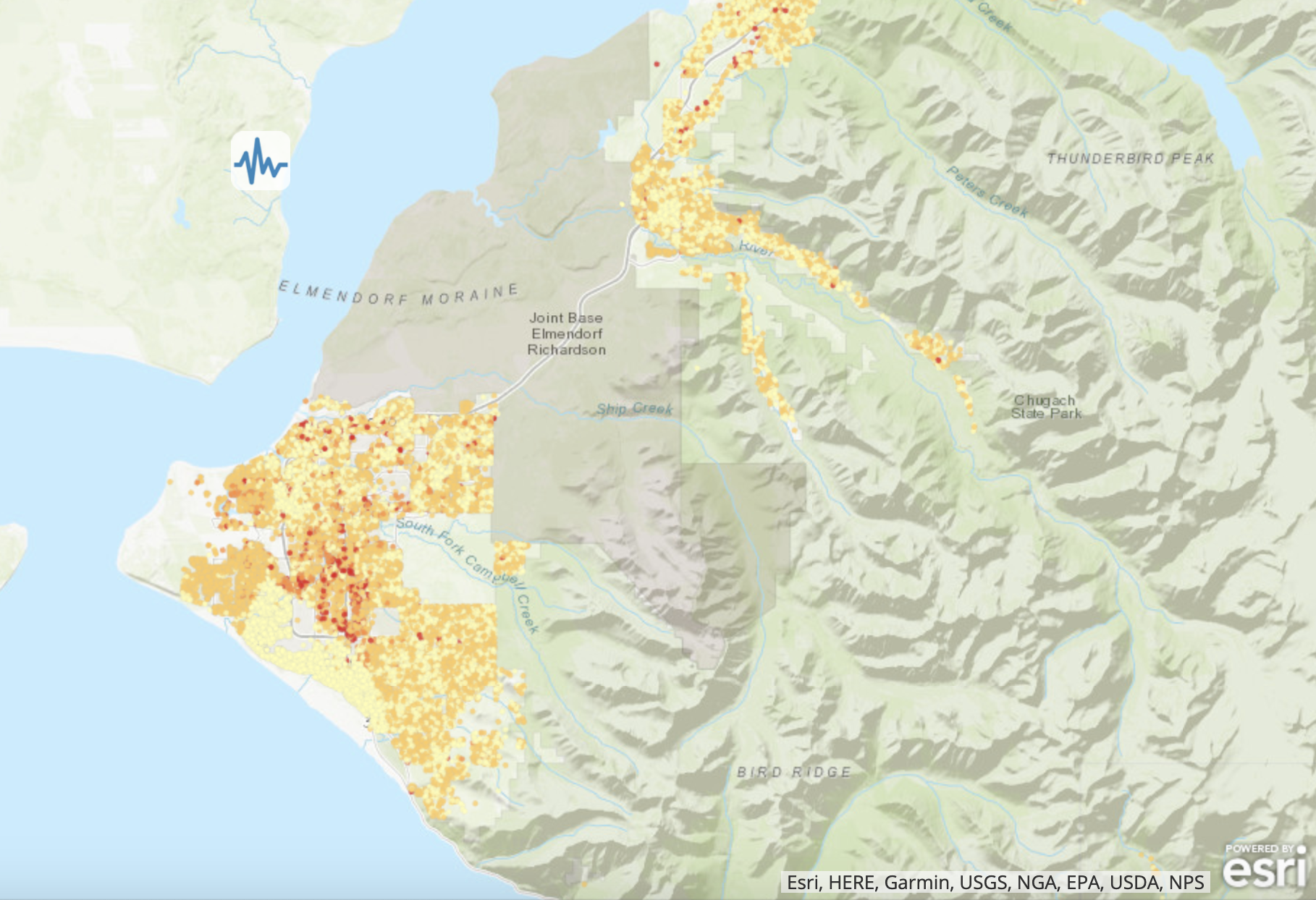
 On November 30, 2018, a Mw 7.1 earthquake struck with an epicenter located 10 miles from Anchorage, Alaska. In the few weeks following the earthquake, the SimCenter team collected and processed building data from public sources. The data was used to run a regional loss estimation that included building repair costs and the number of red-tagged buildings for 85,000 buildings in Anchorage and Eagle River.
An example derived from this testbed is E2 - MDOF, available in the R2D Tool.
This example uses ground motions from the 2018 earthquake in Anchorage, AK, to characterize the response of buildings with an idealized MDOF building model through story-level Engineering Demand Parameters (EDP). Exploiting the refinement in EDPs, a HAZUS-based story-level assessment is employed to evaluate the performance of 10 buildings.
This testbed assesses the performance of 1.84 million buildings in the San Francisco Bay Area in response to a Mw 7.0 earthquake rupture scenario on the Hayward fault. Probabilistic assessment of earthquake consequences with parcel level resolution at this scale was made possible through high performance computing resources at DesignSafe and SimCenters Regional Workflow for Hazard and Loss Estimation (rWHALE). The testbed focuses on assessment of response, damage, repair costs, and repair times for all 1.84 million buildings in the simulation.
Examples derived from this testbed that are available in the R2D Tool include:
E1 - HAZUS
This earthquake example demonstrates rapid analysis capabilities with the HAZUS earthquake damage and loss assessment methodology. Building-level Damage and Losses (D&L) are calculated directly from Intensity Measures (IM) for 25 assets. The IM field that represents peak ground acceleration in the city of San Francisco from an Mw7.0 event on the San Andreas fault, was obtained from Probabilistic Seismic Hazard Analysis (PSHA).
E3 - Physics-based Ground Motions
This example features ground motion acceleration time histories simulated using the SW4 software and a detailed geophysical model of the San Francisco Bay Area by the Lawrence Livermore National Laboratory. The ground motions are used to investigate the impact of a Mw7.0 earthquake on the Hayward fault on the city of Berkeley. Engineering Demand Parameters are simulated with an idealized MDOF building model; building performance is evaluated at the story-level based on the HAZUS earthquake damage and loss assessment methodology.
E5 - Ground Shaking and Liquefaction
This example presents a coupled damage assessment for ground shaking and liquefaction hazards. To infer liquefaction, estimates of horizontal spreading and vertical settlement are generated from PGA values obtained through PSHA. These three intensity measures form the basis of input to a building-level, HAZUS-based damage and loss assessment that accounts for potential collapses due to liquefaction. Approximately 14,000 buildings located in the city of Alameda, California, are considered.
This testbed demonstrates how building inventories can be constructed through automated processes that fuse different data sources to enrich parcel data, using SimCenter applications and heuristic rulesets grounded in local codes/standards and normative construction practices. 
An example derived from this testbed is E7 - Hurricane Wind + Water, available in the R2D Tool.
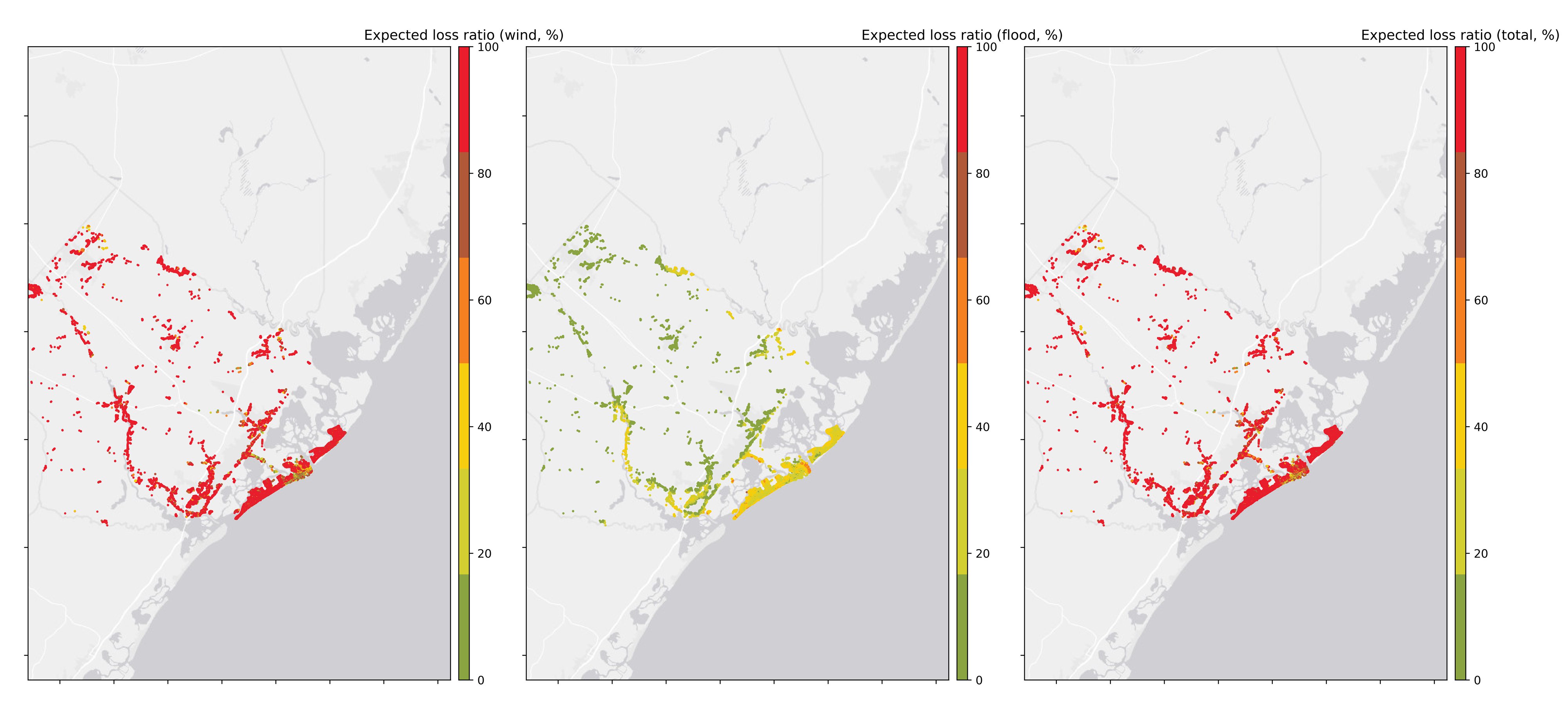
This example presents a damage and loss assessment for buildings under wind and water inundation hazards from a hurricane. Approximately 6,600 buildings with various occupancy types and construction materials are considered in Atlantic City, NJ, with specified rulesets for determining key building characteristics. A Category 5 intensity hurricane with 3-s gust peak wind speeds, obtained from the Storm Hazard Projection Tool (NJCoast project), is employed with HAZUS-Hurricane wind fragility functions to estimate building damage states and loss ratios. The peak wind speeds are calculated using a linear analytical model for the boundary layer winds (Snaiki and Wu, 2017), and the peak inundation heights are calculated from a surrogate model (Jia and Taflanidis, 2013).
This testbed features how inventory generation capacities and existing heuristic rulesets grounded in codes/standards and normative construction practices in coastal communities can be engaged to rapidly generate these loss estimations following a major hurricane.
An example derived from this testbed isE8 - Hurricane Wind, available in the R2D Tool.
This example presents a wind-induced damage assessment for Lake Charles, LA considering the effects of the 2020 Hurricane Laura. Peak wind speed data of Hurricane Laura from Applied Research Associates, Inc. is used as intensity measure, inventory data of about 26,000 wood residential buildings is used along with the rulesets developed to map the inventory to HAZUS-type damage assessment. Final results include the damage and loss estimations along with the building information models based on the rulesets.
The SimCenter envisions that the community will incorporate the underlying workflows of these testbeds into their work by:
Coupling them with other social, societal or economic models, to understand the impacts of hazard events, mitigation investments, and development decisions on community resilience.
Expanding, enriching, and contributing datasets in support of the testbeds to improve the characterization of hazards, the built environment or socio-economic/demographic features.
Incorporating their models (hazard simulations, detailed models of buildings, archetype models of buildings, and fragilities) to provide immediate visualization of broader impacts by demonstrating how it expands our understanding of resilience at larger scales than an individual building.
Contributing new methods, including AI algorithms and UQ methods, to show how they can improve the quantification of built environment performance at large scales.
Using the visualization capabilities to share findings with audiences such as community stakeholders and planners to highlight the results of a mitigation investment, to reveal geospatial distribution vulnerability, and to inform future investments in risk reduction.
Regional Resilience Determination Tool: R2D Tool
Stevan Gavrilovic, UC Berkeley
May 21, 2021
Running Large-Scale Regional Hazards and Loss Simulations
Wael Elhaddad, UC Berkeley
February 25, 2019
Gathering Data for Natural Hazards Engineering Using Web Automation
Wael Elhaddad, UC Berkeley
December 19, 2019
Disclaimer
Testbed simulation results are not representative of any individual building's response. To understand the response of any individual building, please consult with a professional structural engineer. The SimCenter tools do not assert the known condition of the building. Just as it cannot be used to predict the negative outcome of an individual building, prediction of safety or an undamaged state is not assured for an individual building.