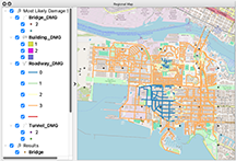

Example 14, Basic HAZUS Transportation
The Regional Resilience Determination Tool (R2D) is a graphical user interface for the SimCenter application framework designed to simulate the regional impact of hurricanes and earthquakes. R2D advances the capabilities of the natural hazards engineering community by facilitating the high-resolution assessment of disaster impact and risk on a regional scale. Researchers can investigate disaster scenarios or perform a probabilistic assessment by considering a diverse set of plausible events and propagate the uncertainty in the hazard and the characteristics of the built environment through the simulations.
New features in the major release of R2D Version 4.0 include:
Download the major release of R2D (V4.0) to take advantage of these features. Major releases are new versions of the application with modifications to the input file format. You will need to update your existing input files to this new format. "Example E14, Basic HAZUS Transportation," provided in the R2D documentation, includes input files that can easily be used as a template.
How to cite:
Frank McKenna, Stevan Gavrilovic, Zsarnoczay, A., Zhao, J., Zhong, K., Barbaros Cetiner, Yi, S.-.ri., Elhaddad, W., & Arduino, P. (2024). NHERI-SimCenter/R2DTool: Version 4.0.0 (v4.0.0). Zenodo.
https://doi.org/10.5281/zenodo.10448043
Gregory G. Deierlein, Frank McKenna, Adam Zsarnóczay, Tracy Kijewski-Correa, Ahsan Kareem, Wael Elhaddad, Laura Lowes, Matt J. Schoettler, and Sanjay Govindjee (2020). A Cloud-Enabled Application Framework for Simulating Regional-Scale Impacts of Natural Hazards on the Built Environment. Frontiers in the Built Environment. 6:558706. DOI: 10.3389/fbuil.2020.558706